
Enhancing Bluetooth Location Services with Direction Finding
Executive Summary
The market opportunity for Bluetooth® location services has grown rapidly over the last few years, with industry forecasts now predicting over 400 million products in this solution area shipping per year by 2022¹.Today, Bluetooth point of interest (PoI) information solutions are enhancing the visitor experience within museums and retail stores around the world. Millions of people rely on Bluetooth item finding solutions to track down lost keys and other personal items. Bluetooth indoor positioning systems (IPS) are helping millions of travelers navigate through busy airports and shoppers through malls. And warehouses and facilities around the globe are using Bluetooth realtime locating systems (RTLS) to better manage resources and optimize the flow of materials.Despite this tremendous success, the Bluetooth community does not remain idle and continually seeks to enhance the technology. The communityrecently added a direction finding feature that has the potential to significantly enhance the performance of Bluetooth location services solutions.
Introduction
One key reason for the incredible success of Bluetooth is its unique approach to market. With Bluetooth, developers get more than just a radio technology, they get complete, full-stack, globally interoperable solutions that address various wireless connectivity needs.Bluetooth does not seek to be the best solution for all wireless connectivity needs, but if you are a developer building a solution that needs to stream audio between two devices, a solution that needs to transfer data between two devices, a location services solution, or a solution where you need to have tens, hundreds, or even thousands of devices communicating with each other in a secure, reliable mesh network, then Bluetooth strives to be the best technology available.This focus on delivering complete, globally interoperable solutions for specific solution areas has played a significant role in establishing Bluetooth as the technology of choice for many developer communities. And the Bluetooth community is continually working to enhance the technology to better meet developer needs in these various solution areas.
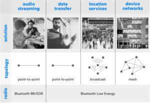
The introduction of Bluetooth Low Energy in 2010 gave developers the ability to start leveraging Bluetooth to create powerful, low-cost real-time locating systems, indoor positioning systems, item finding solutions, point of interest (PoI) information solutions, and more. In just a few years, location services has become one of the fastest growing solution areas for Bluetooth, and it is expected that over 400 million Bluetooth devices supporting location services solutions will be shipping per year by 2022.
Bluetooth Location Services
Until now, all standard Bluetooth location services solutions have been developed using the same basic building block. They leverage the Bluetooth Low Energy radio to determine if two Bluetooth devices are in range of each other and, in many cases, use received signal strength (RSSI) measurements to estimate the distance between the two devices. That basic ability to determine whether another device is nearby and approximately how close as led to the creation of a number of compelling Bluetooth location services solutions. These solutions generally fall into two categories: proximity solutions and positioning systems.
Bluetooth Location Services
 item finding solutions (e.g. personal property tags)
 point of interest information solutions (e.g. proximity marketing)
 real time locating systems (RTLS) (e.g. asset tracking)
 indoor positioning systems (IPS) (e.g. wayfinding)
Bluetooth Proximity Solutions
Proximity solutions are the simpler of the two categories and leverage Bluetooth to determine the location of two devices relative to each other. One Bluetooth device, generally a smartphone, is used to determine if another Bluetooth device is within range and, in many cases, approximately how far away. Point of interest information and item finding are two of the most popular Bluetooth proximity solutions.
PoI Information Solutions
Point of interest information solutions were one of the first Bluetooth location services to come to market. In a PoI information solution, small, battery-powered Bluetooth transmitters, often referred to as beacons, are deployed throughout facilities to improve the visitor experience. Beacons deployed in museums can provide visitors with more information about exhibits while beacons in retail establishments can provide nearby shoppers with additional product information. In these solutions, the visitor typically downloads an application to their smartphone that enables the Bluetooth radio in their phone to listen for nearby beacons and then presents more information to the user based on the beacon or beacons it hears.

Item Finding Solutions
Item finding solutions have been experiencing tremendous growth over the last few years. These solutions involve small, battery-powered Bluetooth devices, often referred to as personal property tags, that can be attached to movable objects like a set of keys or a wallet. They also include an application that enables the Bluetooth radio in smartphones to listen for and estimate the distance of specific tags.

Bluetooth Positioning Systems
Positioning systems use Bluetooth to determine the physical location of devices and involve moresophisticated infrastructure deployments. Real-time locating systems (RTLS) and indoor positioning systems (IPS) are two of the most popular types of Bluetooth positioningsystems.
Real-time Locating Systems
Bluetooth RTLS solutions are used for both asset tracking as well as people tracking. For example, these solutions can locate and track the position of pallets, forklifts, and workers in a warehouse, or ultrasound machines and patients in a hospital, helping to ensure safety and optimize response time in an emergency. Bluetooth RTLS solutions are based on the deployment of Bluetooth receivers, often referred to as locators, in fixed locations throughout a facility.The locators connect back to a centralized server, often referred to as a location engine. Low-power, battery-operated Bluetooth transmitters, commonly called tags, are then attached to all assets (or people) that the system is intended to track.
The tags are programmed to transmit a signal on a periodic basis, the frequency of which is determined based on how mobile the tracked assets are expected to be, as well as how realtime location estimates need to be. Each locator continually reports back to the location engine all tags it can hear, as well as the received signal strength (RSSI) from each. The location engine uses that information, as well as the known position of each locator, to estimate the position of tags based on a process called trilateration.Trilateration determines the position of an object by understanding its distance from three known reference points. In the case of Bluetooth, locators estimate their distance to any given asset tag based on the received signal strength from the tag.The accuracy of location estimates is influenced by several factors, including the floor plan of the facility and the number of locators deployed. Current standard Bluetooth RTLS solutions can provide meter-level accuracy (~1 to 10 meters).
Indoor Positioning Systems
Bluetooth indoor positioning systems power way finding solutions that help visitors, such as shoppers in a mall, travelers in an airport, or workers in a large office building, navigate their way throughout a facility. Bluetooth IPS solutions work in the opposite way as RTLS solutions. Instead of Bluetooth receivers, Bluetooth transmitters, commonly referred to as locator beacons, are deployed in fixed locations throughout a facility. Visitors then use an app on their smartphone that enables the Bluetooth radio in the phone to listen for locator beacons. Based on which beacons the app can hear, along with the received signal strength (RSSI) from each and their known locations, the app is able to use trilateration, the same process used in RTLS solutions, to calculate its current position. Like RTLS solutions, the location accuracy of Bluetooth IPS solutions is influenced by several factors including the floor plan of the facility, as well as the number of fixed locator beacons deployed, but current systems can provide meter-level accuracy (~1 to 10 meters).

Bluetooth Direction Finding
While Bluetooth location services have seen tremendous success based on current capabilities, there is market demand for solutions that can provide even greater performance.For example, in some RTLS deployments, it is important for the system to provide location accuracy down to centimeter-level. Fortunately, a well-established capability has recently been added to Bluetooth technology that will enable the development of location services solutions that can achieve these advanced performance requirements.Radio direction finding refers to the practice of determining the direction from which a received signal was transmitted. Radio direction finding has been in practice since the early twentieth century and is used in systems to support everything from aviation and nautical navigation to wildlife tracking.
 Since the early twentieth century, radio direction finding has been used to support everything from aviation and nautical navigation to wildlife tracking.
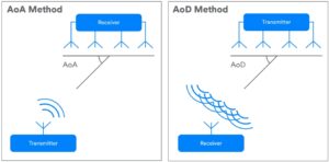
In version 5.1 of the Bluetooth Core Specification, Bluetooth added an optional direction finding capability. Using this new feature, a Bluetooth device can determine the direction of a signal being transmitted from another Bluetooth device. This seemingly basic capability has the potential to significantly enhance Bluetooth location services solutions.As discussed above, Bluetooth location services are currently using RSSI to estimate the distance between two devices and, in the case of RTLS and IPS solutions, use those distance estimates and trilateration to determine the position of a device. Now, with direction finding, those same devices can also use information about the direction of another device and, for RTLS and IPS solutions, use triangulation to improve location accuracy. The Bluetooth direction finding feature supports two methods for determining the direction of a Bluetooth signal, both of which are based on the use of an antenna array; angle of arrival (AoA) and angle of departure (AoD).
Direction Finding Using Angle of Arrival Method
In the angle of arrival (AoA) method, the device to which direction is being determined, such as a tag in an RTLS solution, transmits a special direction finding signal using a single antenna. The receiving device, such as a locator in that same RTLS solution has multiple antenna arranged in an array. As the transmitted signal crosses the array, the receiving device sees a signal phase difference due to the difference in distance from each of the antenna in its array to the transmitting antenna. The receiving device takes IQ samples of the signal while switching between the active antenna in the array. Based on the IQ sample data, the receiving device can calculate the relative signal direction. The AoA method of direction finding is intended for use with RTLS, item finding, and PoI information location services solutions.
 Bluetooth direction finding using angle of arrival (AoA) Bluetooth direction finding using angle of departure (AoD)
Direction Finding Using Angle of Departure Method
In the angle of departure (AoD) method, the device to which direction is being determined, such as a locator beacon in an IPS solutions, transmits a special signal using multiple antenna arranged in an array. The receiving device, such as a mobile phone in that same IPS solution, has a single antenna.As the multiple signals from the transmitting device cross the antenna in the receiving device, the receiving device takes IQ samples. Based on the IQ sample data, the receiving device can calculate the relative signal direction. The AoD method of direction finding is intended for use in IPS solutions, such as those used for wayfinding.
Bluetooth Profiles with Direction Finding
For many Bluetooth features, profile specifications are published that define how to develop interoperable Bluetooth products that implement the feature. For example, the Bluetooth Headset Profile defines how to develop interoperable audio headsets using Bluetooth.This is also true for the new Bluetooth direction finding feature. Several new profiles are in their final stages of development and are expected to be released soon, including a profile for products implementing direction finding using the AoA method and a profile for products implementing it using the AoD method.
Enhancing Bluetooth Location Services Solutions Using Direction Finding
The Bluetooth community added direction finding capability in response to market demand forBluetooth based location services solutions that could deliver even greater performance. By addingthe direction finding feature, Bluetooth proximity solutions can add directional capabilities whileBluetooth positioning systems can improve location accuracy.Item Finding Solutions – Should smartphone vendors choose to include Bluetooth direction findingwith AoA support in their products, item finding solutions could be enhanced to provide directionalinformation. With direction finding support, in addition to identifying how close a misplaced item is,an item finding application on a smartphone could also determine the item’s direction, improving theuser experience.PoI Information Solutions – PoI information solutions could also benefit from direction finding withAoA being added to smartphones. Imagine a room in a museum with multiple exhibits that have associated beacons. With direction finding support, a PoI information application on a smartphonecould not only inform a user of all the exhibits in the room and allow them to select one to receive additional information, but the user could simply point their smartphone at a specific exhibit to get more information on that item. RTLS Solutions – By implementing direction finding, RTLS solutions could improve location accuracy down to centimeter-level, depending on deployment considerations. By deploying a RTLS solution with direction finding support, a factory could track the location and flow of materials with greater precision, as well as track and alert workers before they go into unsafe work areas.IPS Solutions – IPS solutions with direction finding support deployed in hospitals or shopping malls could provide even greater positioning accuracy to improve the navigation experience or require the deployment of fewer locator beacons.
Conclusion
The Bluetooth community is continually enhancing the technology to address new marketopportunities while meeting the ever-expanding needs of the markets in which it already participates.With the introduction of the Bluetooth Low Energy radio, the community sought to address themarket opportunity for standardized, lower-cost location services solutions. With Bluetooth locationservices solutions now predicted to be shipping 400 million products per year by 2022, it wouldappear the community has been successful in achieving that goal.However, the community never sits still. Despite the success Bluetooth location services solutionshave seen based on current capabilities, the community saw market demand for solutions thatcould deliver even greater performance, such as Bluetooth RTLS solutions that could achieve truecentimeter-level location accuracy. To meet this need, the community added a direction findingfeature to Bluetooth.The addition of direction finding brings established, time-tested methods for determining signal direction to a proven, trusted radio. This feature will enable Bluetooth proximity solutions to add directional capabilities that enhance the user experience as well as Bluetooth positioning systems that can address the full spectrum of positioning use cases, from common low resolution systems to the most precise.
Enhancing Bluetooth Location Services Instruction Manual – Enhancing Bluetooth Location Services Instruction Manual –